Historical map challenge tests knowledge of Sussex town
and live on Freeview channel 276
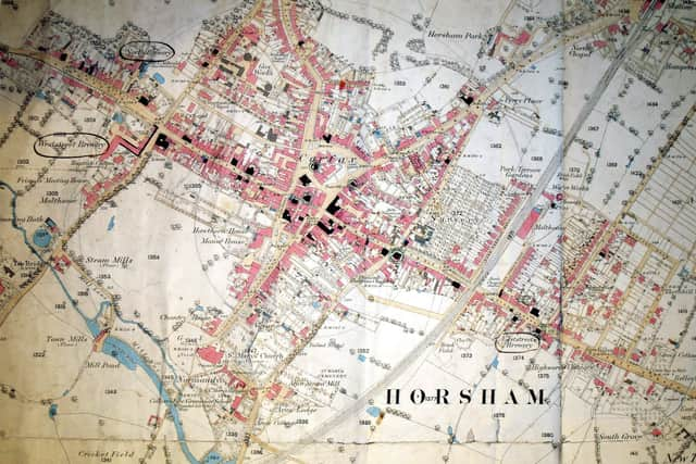
Horsham Museum & Art Gallery heritage manager Jeremy Knight has been exploring the Tithe Map, produced in 1841 and revised in 1846, and explains it does have some drawbacks.
He compares it to the Ordnance Survey map of around 1875, used by solicitors to plot licensed premises, and has come up with a list of challenges and things for people to find to test their knowledge of the town.
Advertisement
Hide AdAdvertisement
Hide AdJeremy said: “It is a fantastically detailed map. It is an extremely useful resource but has some drawbacks. It is extremely large, filling a room, and only three copies were made.

“Whilst a map that related to Horsham Parish and town had been drawn up as an attachment to the 1832 Reform Act, it lacked real detail. Very few people would have had access to a copy of the act, thus making this map all the more important.
“Maps were originally produced for individuals, often to fulfil a particular purpose such as clarifying land ownership or for showing off one’s estate.
“Horsham appears on the best medieval map of Britain, the Gough map, an engraved copy of which done in 1780s of the map. For some reason, the hamlet of Stopham is shown on the map but a number of larger settlements are not.”
Advertisement
Hide AdAdvertisement
Hide AdHave a look at www.goughmap.org for more detailed information on this amazing but largely-forgotten map.